- Home
- About Us
- Resources
- Events
- Members Only
- Contact Us
- Join Now
|
Climate change is a major threat to both coastal and inland communities in the southeastern United States. There are multiple ways to assess flood risk through various modeling and data analysis approaches. As we all look to better understand risk for future planning, the following briefly discusses approaches for inland and coastal community stormwater system modeling.
While traditional design storm modeling falls short in the assessment of climate change scenarios there are several approaches that can be used to improve H&H modeling for climate change including: continuous rainfall simulations using updated rainfall projections, stochastic storm translation, or adjusting outdated Atlas 14 rainfall data. These methods can help communities model scenarios like roadway overtopping, scour, riverbank erosion, pinpointing areas, and infrastructure at risk. Coastal communities face additional unique flooding threats. These include storm surge, tidal or sunny day flooding, and compound flooding. One of the most significant threats to infrastructure for planning in coastal areas are storm impacts, including surge and waves. This threat is further exacerbated by the effects of climate change, i.e., sea level rise (SLR), more frequent and intense storms. While FEMA has developed detailed maps that quantify areas of inundation, they are only based on present sea level conditions and storms. Therefore, FEMA risk maps are not valid for the assessment and development of resilient coastal infrastructure. A range of approaches and methodologies have been utilized to quantify storm flooding to account for climate change. The most basic approach utilizes present day projections and applies the projected SLR condition (bathtub approach). While highly simplified, in certain situations, this approach has been shown to provide reasonable results. See links below to view FEMA data along with information on surge conditions. This approach is often supplemented by accounting for potential changes in wave conditions due to increased depths using models such as WHAFIS or SBEACH. Direct modeling of future SLR surge conditions can be accomplished using numerous modeling tools. A model used by FEMA is the ADCIRC model. Other commonly used data are based on the NOAA SLOSH model. These models can provide direct simulation of surge conditions under future SLR and storms. See links for FEMA (Flood Map Service Center Search / Mapping Information Platform), surge information (Coastal Hazards System, V2.0 / NHC Storm Surge Risk Maps) and NOAA (SLR Viewer / Data Access Viewer) Incorporating these modeling approaches into Master Plans and Capital Improvement Plans (CIPs) is key to building community resilience. Master Plans can include new zoning rules to limit building in flood-sensitive areas. Meanwhile, CIPs can set aside funds for specific projects, such as upgrading stormwater systems or constructing flood barriers. Incorporating a changing climate into H&H or surge models will inform Master Plans and CIPs; allowing inland and coastal communities to take proactive steps to reduce the risks. This data-driven approach enables communities to prepare for, rather than simply react to, potential disasters, enhancing their resilience and long-term sustainability. |

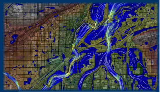 Inland communities, especially in the Southeast, are being affected by the changes in climate and weather patterns, with more frequent and severe flooding and extreme weather events. To address these challenges, hydrologic and hydraulic (H&H) models such as HEC-RAS (1D & 2D), PCSWMM, and Autodesk Infoworks Integrated Catchment Model (ICM) are useful tools. These tools have varying costs ranging from free (HEC-RAS) to more expensive proprietary options. Note PCSWMM is approximately 1/10 the cost of ICM annually. HEC-RAS is commonly used for simulating streams and river system hydraulics and floodplain mapping using 1D and
© Southeast Stormwater Association
PO Box 16098
Tallahassee, FL 32317
1-866-FOR SESWA (367-7379)
[email protected]
Back to top